
In the far southwest of Britain lies The Land’s End peninsula of Cornwall. The ancient Greeks called it Belerion, ‘the shining land’; today we call it Penwith. Jutting out deep into the mighty Atlantic Ocean, this part of Cornwall is distinct from the rest of the county. The area is famous for its world class beaches, with azure-blue coves that seem closer to the Mediterranean than England, but there is far more to this rugged corner of the country than water alone.
Long ago, this peninsula would have been almost cut off from the mainland by larger rivers and higher water levels, making it seem even more remote. The landscape here is characterised by brooding hills with slanted trees, weather-beaten by harrowing winds from the ocean. Beneath your feet is a colossal foundation of granite stretching all the way to Devon, connecting the hilltop crags we see here to the tors of Bodmin Moor and Dartmoor. This rock formation also contains precious minerals which historically made Cornwall one of the world’s most important mining areas.
Of primary importance was tin, used to make bronze, which kickstarted the use of metal around the world and a bedrock of civilisation as we know it. There are few places on Earth with tin deposits as rich as Cornwall, meaning that this has been an important area since before history began: we know that bronze artefacts found in the Mediterranean, over 5,000 years old, were made using Cornish tin. Yes, that means that Cornish tin was in demand around the world at the same time that Stonehenge was being built! The location of Penwith made it easy for traders and cultures to access.
As demand for tin grew, so did the mining efforts: by the time of the Industrial revolution, thousands of engine houses had been built to access minerals hidden deep underground. Cornwall was famous for producing the world’s finest miners, although the life was a difficult one: many had their lives cut short by accidents and poor working conditions. This area was so important that the entire mining landscape was designated a UNESCO World Heritage site. The remains of these engine houses are still visible today, like the weathered bones of a bygone era.
Mining may have given Cornwall its important role in the world’s Bronze Age, but there are also Stone Age relics here which have endured for even longer than the invention of metal. The Penwith peninsula has the highest concentration of neolithic sites in Europe: stone circles, underground temples, burial cairns, standing stones, holy wells, hillforts, ancient villages, and mysteries whose true purpose lies beyond the mists of time. These are made more impressive by the fact that they are unique to this area, distinct from sites throughout the rest of Britain and even the rest of Cornwall: they are closer to those found in Brittany or Ireland. Here it seems you can’t walk a hundred yards without stumbling on some remnant from prehistory, that if found in isolation would be very impressive, but in a concentration like this gives the impression that you really have entered a different realm altogether.
These ancient remains are just one reason why the entire peninsula seems to be clouded with secrets and magic, always hiding just around the corner, waiting for those with the will to discover it. The spirit of the nature-worshipping Celtic druids and of the ‘pagan’ Celtic Christianity that followed it still lingers here, unlike more developed areas of the country where it has been built upon or scrubbed out altogether. The stones and the land keep their memory and it is not difficult to imagine a time when ‘the old gods’ ruled these places which have probably not changed very much at all.
And so we have the chance today to walk through a rugged, semi-tamed landscape that passes barely a scattering of houses, but takes in a procession of sites stretching thousands of years across the history of Cornwall, civilisation and spirituality; all built from the stones that make up this extraordinary part of the world. Set aside an afternoon to venture inward from the coast, and be rewarded with the chance to connect with the very soul of one of Britain’s wildest corners.

ROUTE DETAILS
Time: 4 hours (about 3 miles)
Terrain: Stone paths and grassland with a few stiles. Some uneven ground so boots are best. You might encounter cows so be careful if you have a dog
How to get there: There is room to park at the start of the walk here. From Penzance it’s a 90 minute bus and 20 minute walk
Directions: Google map route with written directions here
Refreshments: Nothing for miles around. There’s a shop in Pendeen and a superb pub called The Gurnard’s Head which does amazing food
Notes: There are plenty of opportunities to extend this walk as there are so many fascinating sites to see - however due to spending ages at each site this was all we managed in an afternoon. Feel free to extend if you like
THE ROUTE
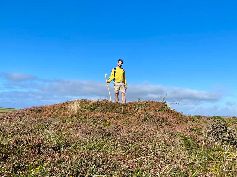
Your portal into this ancient landscape is the Tinners Way, an ancient track connecting St Ives to Cape Cornwall. This path is as old as tin mining itself, and so has been pounded by tin miners for thousands of years. As you walk in their footsteps along the rocky lane, you can imagine them hauling their hard-found ore to the coast to be traded with exotic merchants from faraway lands.
Where there's a mine or a hole in the ground
That's what I'm heading for that's where I'm bound
So look for me under the lode and inside the vein,
Where the copper, the clay, the arsenic and tin
Run in your blood and under your skin
- Cousin Jack, The Countrymen
Mên-an-Tol
The first stone monument you encounter is one of Cornwall’s most famous. A short detour off the path brings you to the Mên-an-Tol, which is Cornish for 'stone with hole'. To the uninspired eye, a stone with a hole is all there is, along with a few nearby standing stones made of granite. But to others it’s known as the Crick Stone or the Devil’s Eye, due to its magical properties that have been revered for as long as anyone can remember.

This site has been used for rituals of all kinds, most commonly for health purposes. Passing through the hole a certain number of times is said to cure: bad backs (hence the name Crick stone); rheumatism; scrofulous taint, AKA tuberculosis (why aren’t we calling it scrofulous taint anymore?) and rickets in children. In fact, children were passed through the hole as an act of ‘baptism’ to ensure good health during their lifetime. Farmers used it hoping for fertility blessings, and women passed through it backwards to encourage pregnancy. Generally the rituals involved walking around and/or through the stone a number of times, often nine: the magic was meant to be strongest at dawn, dusk, full moon or new moon. Feel free to invent your own ritual - but don’t blame me if anyone accidentally gets pregnant!
Some say the stones have a fairy or piskie guardian who can help tell the future or make miraculous cures. In one story, evil piskies had stolen a baby and replaced it with a changeling, which was was passed through the hole in the stone to reverse the spell and return the real child to it’s mother. Intriguingly, the inside edges of the hole have levels of radiation almost twice as high as the surrounding environment. Could the two be linked?
Whatever your thoughts on fairies, there is surely something at play here to sustain the legends of this place. Are these stones really magical? Maybe they have been revered for so long that countless generations of ritual and belief have infused them with some kind of energy? Or maybe any blessings are simply due to the placebo effect; although with our current understanding this can certainly seem like a form of magic. Think about a church, which is more old stones on a bigger scale. People wouldn’t doubt that churches are sacred and filled with spiritual energy; if it can work for a church then why not a stone with a hole?

Mên Scryfa
A short distance further along the Tinners Way is a green field punctuated with a single standing stone. This stone is known as the Mên Scryfa: and commemorates a great battle that took place on this spot long ago. Inscribed on the stone’s northern face is RIALOBRANI CVNOVALI FILI (the FILI is now buried) which means ‘Royal Raven, son of the famous leader’. The inscription is about 1500 years old.
“There is an old story of an invader seizing the lands of the ‘Glorious Leader’ and occupying his hillfort stronghold at Lescudjack; the defeated royalty being forced to flee, possibly to the hillfort of Caer Bran (Raven Castle). The young warrior tried to regain his father’s territory and a great battle was fought on the moors by Mên Scryfa. Rialobran was killed and his body buried by the stone, which is supposed to correspond to the height of the dead man - the the full length was just under ten feet! The very existence of the monument suggests that the battle was won and ancestral lands retaken.” - Ian Cooke
Whatever the truth of the tale, it’s thrilling to imagine that once upon a time this was a battlefield between two armies, which seems so far removed from history and memory that it gains an almost mythical quality. Now all that remains to this day is this stone and this field, with the twin peaks of Carn Galva rising in the distance.

Soon after, you’ll reach a crossroads marked by a big fallen stone: this is the Four Parishes stone, also known as Mên Crows (stone cross). This marks not only the meeting point of four paths but also the boundary of the four parishes of Zennor, Gulval, Madron and Morvah. All of which sound a bit like witches to me.
BONUS: About 150 metres south of the Four Parishes stone is Venton Bebibell, or ‘Well of the little people’. The source of the river Newlyn, and a longstanding tradition where children would ‘baptise’ their dolls in it on Good Fridays. It was only recently rediscovered and it’s still an effort to get to: you can find it next to a hedge and an old tree. Did the tradition come from the well’s association with ‘the little people’ being fairies and piskies? Make a detour and find out for yourself.
Continue up the hill, through a thick carpet of heather, with bright yellow tormentil flowers in the summer and the chance to see Hen Harriers or Short Eared Owls in the winter. Note the raised Bronze Age cairns beside the path which seem to be aligned to Carn Galva behind you.
Boskednan Stone Circle
This site, also known as the Nine Maidens, would have had many uses, from ceremonies to celebrations and social gatherings. On a good day, this impressive spot has commanding views of the surrounding moorland and distant sea, as well as several landmarks. The two largest stones are placed so that they frame the rocky outcrop of Carn Galva when viewed from the centre of the circle, suggesting that these distant peaks hold a longstanding spiritual significance.
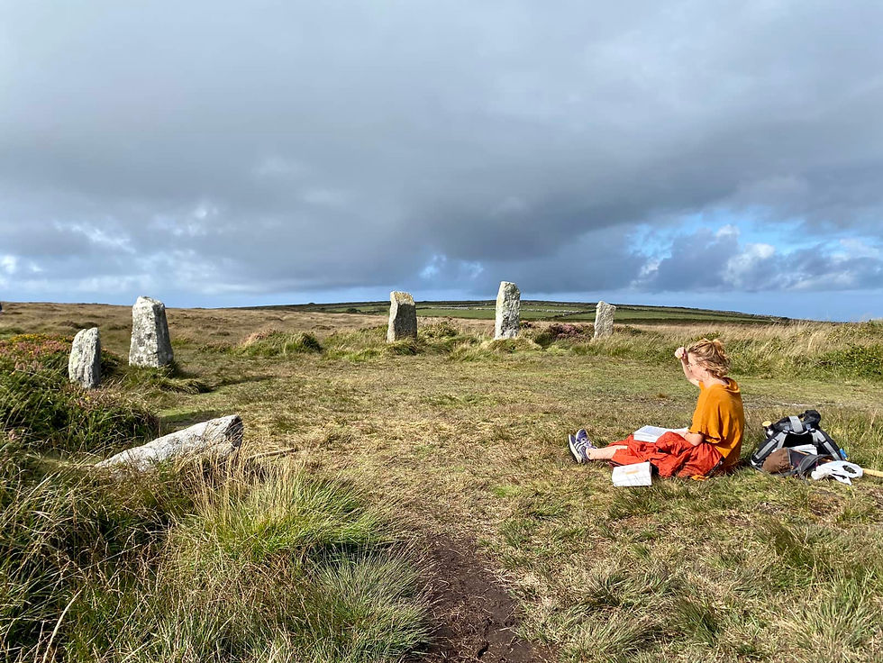
This is one of four remaining Bronze Age stone circles in the Land’s End peninsula: but all of them are called Nine Maidens, as well as other stone circles in Cornwall, Devon and beyond. In every case, there is a legend that a group of maidens were turned to stone by God for dancing on the Sabbath. The likely origin of this legend lies with the Church’s wish to scrub out any lingering pagan beliefs, especially in Cornwall where Christianity had become intertwined with long-held pagan spirituality. The threat of petrification would have been a handy way to denounce these stone circles and steer local folk away from old beliefs and into churches. But why nine, when there are always more than nine stones? It could be a mistranslation of the Cornish for ‘stone’; or it could reference that nine was traditionally held as a sacred feminine number. The circle shape also suggests these places were associated with feminine power, something that medieval God really wasn’t into, along with dancing and having fun on Sundays.
This stone circle was the inspiration for a Celtic Opera called Lernin, which is about one of the stone maidens coming back to life as a fairy. The writer, George Lloyd, said this:
“You see for me, I half believe that a stone can become a woman! This whole magic business – I know I don’t believe it, but I still think it is in the realms of possibility. I always felt that. As because as the tenors said ‘these stones they seem to have life to me,’ and all that country, that whole thing, whole atmosphere of the place of West Penwith, it seemed alive to me, and then when I looked and thought about Lernin, I said, yes, I half believe all that, and half believing is better than not believing at all.”
BONUS - Make sure to check out the nearby barrow hidden in the gorse, very unusual to be so close to a stone circle. A decorated Bronze Age urn was found buried here, made at least 1,000 years before the Romans arrived in England.
If you want, you can extend your route by heading from here to Bodrifty Settlement and Mulfra Quoit (both marked on OS Maps) for more examples of how the prehistoric peoples of this land lived and died here.
Otherwise, make your way across the moor toward the great chimney of Greenburrow engine house on the horizon. As you proceed, more of Mount’s Bay will become visible in the distance, and soon you’ll be traversing a heavily mined landscape: don’t stray from the paths, as beneath the bracken and gorse are hidden pits and holes that will gobble up anyone silly enough to go near them!
Ding Dong Mine
The Ding Dong mines are reported to be the oldest in the Westcountry, and possibly in Britain, dating back to prehistoric times.

Old legends tell that the mine here was worked hundreds of years before the ‘time of Christ’: other legends suggest that Joseph of Arimathea visited the area accompanied by the young Jesus, who personally addressed the miners, and that this was the source of the copper for King Solomon’s temple - although naturally there is no evidence for any of these! What we do know is what was written by Diodorus of Sicily, 100 years before the Romans first invaded Britain:
The inhabitants of Britain who dwell about the promontory known as Belerion are especially hospitable to strangers and have adopted a civilised manner of life because of their intercourse with the merchants of other peoples. They it is who work the tin, treating the bed which bears it in an ingenious manner. This bed, being like rock, contains earthy seams and in them the workers quarry the ore, which they then melt down and cleanse of its impurities. Then they work the tin into pieces the size of knuckle-bones and convey it to an island which lies of Britain called Ictis…where merchants purchase the tin of the natives and carry it from there across the Straits of Galatia…”
From this we can see that proper tin mines did exist at the time, and so perhaps this mine is indeed the oldest. In the 13th century the name of the mine here was ‘Dindods’ which presumably changed to Ding Dong Mine, a Mario Kart level just waiting to be made. In its heyday, the mine employed over 274 miners, who each month used 900lbs of candles and 300lbs of gunpowder. No wonder there are so many holes in the surrounding landscape.
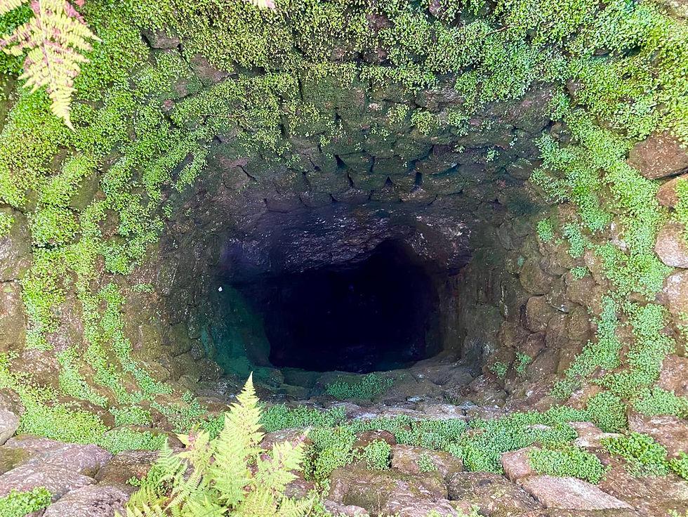
The building here is the Greenburrow engine house (Grade II listed and an important part of the UNESCO World Heritage Landscape), and the largest connected to the Ding Dong mine network. This engine house is so named because it would have contained a huge engine designed to pump water out of the 480 foot deep Greenburrow shaft nearby. You can see how deep this shaft goes (and how brave you are) by standing on top of the grate and dropping a stone down. And that probably isn’t even the deepest bit of the mine!
BONUS - Heading west from the mine, not far from the footpath is Bosiliack Barrow: marked on OS maps as a tumulus, but in reality so much more. This circular barrow is a chambered tomb, with an entrance passage facing the midwinter solstice sunrise, thought to link the power of rebirth of the sun with the spirits of dead ancestors. This would once have been covered in earth, but this is one of the most precisely excavated barrows on the peninsula: so worth checking out to get a real sense of it.
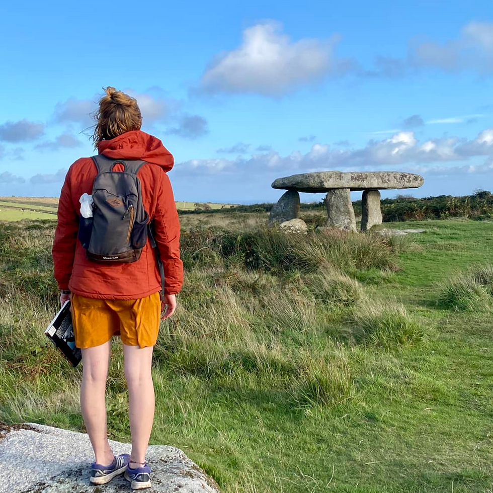
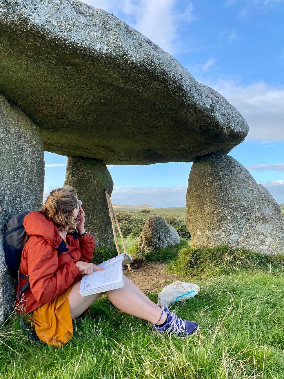
Lanyon Quoit
A short detour from the footpath will bring you to a patch of moorland with a spectacular quoit: a collection of monumental stone slabs with one perched on top, constructed thousands of years ago as a burial chamber.
These granite mammoths would have formed the walls and roof of a burial chamber before being covered with earth: over millennia the earth has worn away, leaving only the bones. Quite similar to how the granite rocks end up on top of hills actually: like an invisible archaeologist’s brush gently sweeping away earth to reveal long lost clues as to who we used to be.
This is probably one of Penwith’s best known stone monuments - but it is only a poor reconstruction of a magnificent original, which collapsed in 1815 during a violent storm. It was rebuilt, but with less stones and on a smaller scale. Records from before the storm show that the 13 ton capstone was so far off the ground that a man on horseback could supposedly pass beneath it. Like many other stone monuments, this begs a tantalising question: how on earth did people lift a 13 ton stone up this high when they were still living in huts? It reminds us that there is still much we don’t know about how these people lived. All the more reason to use our imagination. Nonetheless, even if this is a pale imitation of the original, this is still a fascinating site, and a good spot for contemplating the mysteries and majesties of the land that surrounds you.
BONUS - Before you head back to the starting point, you will pass a field containing West Lanyon quoit. It’s private property but the story alone is worth relaying. It was rediscovered in 1790, when the landowner took shelter nearby and eventually realised there was something buried here. He ordered his servants to dig away the earth, eventually revealing a cromlech (tomb with the earth still on it). When he realised this, he bade his men to dig under it, where they found a broken urn with ashes, and digging deeper still, the fractured skeleton of a human body. Not long after this, the landowner suffered from the failure of his crops and death of his cattle. What could have caused such misfortune…?
As you finish your walk, reflect on the variety of sites you have visited today, spanning thousands of years from magical origins to industrial powerhouses. You have journeyed across not only land but time: by appreciating these sites, you keep their story alive and in turn become a small part of it yourself. And that’s pretty cool in my book.
My final note is that the house opposite the start/end of the walk belonged to Ian Cooke, who was my inspiration for this adventure. Ian is an artist who moved to Penwith and loved it so much that he wrote an amazing book called ‘Journey to the Stones: Ancient Sites and Pagan Mysteries of Celtic Cornwall’ first published in 1980, which provides guided walks around the Penwith peninsula and all the mindboggling history and details to go with it. I was given this book secondhand for my birthday, and we decided to make a walking holiday out of it. It was an incredible week of discovery and adventure and is the basis on which I’m writing this post. There is something to be said for walking around the landscape following an old book with illustrations rather than the GPS on your phone for a change. If Alfred Wainwright could do it for the Lake District then this is certainly Penwith’s answer. Passion is infectious and Ian definitely rubbed off on me! In Ian’s words: “Keep on walking the stones”

Comments